If you might of noticed, I took that quote from the movie Grease. Sandy in the film was a Kind, Honest and a sweetheart, but this storm will not be Kind, It wont be Honest and It for sure wont be a sweet heart. Other than this post being entitled after a quote from the film and a reference to how the character is portrayed, lets get down to business.

© 1978 - Paramount Pictures

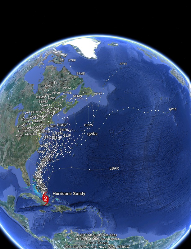
GOES-EAST VISIBLE - OCT 25 12 11:15PM
The weather hasn't "scared" me for a long time, but what I'm seeing tonight on the forecast models, and the seriousness with which I'm seeing famous meteorologists discuss next week's historic storm, has gotten me a little worried. If you live in any STATE on the East Coast, it's time to think about preparing for next week's storm because the track is not certain but the potential devastation seems to be. Some simple steps can keep next week from being a nightmare for you and your family. WITH THE LATEST MODELS I CANT NOT HELP BUT TO URGE YOU HAVE THE FOLLOWING:
Emergency Supplies:
Water, food, and clean air are important things to have if an emergency happens. Each family or individual's kit should be customized to meet specific needs, such as medications and infant formula. It should also be customized to include important family documents.
Recommended Supplies to Include in a Basic Kit:
- Water, one gallon of water per person per day, for drinking and sanitation
- Food, at least a three-day supply of non-perishable food
- Battery-powered radio and a NOAA Weather Radio with tone alert, and extra batteries for both
- Flashlight and extra batteries
- First Aid kit
- Whistle to signal for help
- Infant formula and diapers, if you have an infant
- Moist towelettes, garbage bags and plastic ties for personal sanitation
- Dust mask or cotton t-shirt, to help filter the air
- Plastic sheeting and duct tape to shelter-in-place
- Wrench or pliers to turn off utilities
- Can opener for food (if kit contains canned food)
Clothing and Bedding:
If you live in a cold weather climate, you must think about warmth. It is possible that the power will be out and you will not have heat. Rethink your clothing and bedding supplies to account for growing children and other family changes. One complete change of warm clothing and shoes per person, including:
- A jacket or coat
- Long pants
- A long sleeve shirt
- Sturdy shoes
- A hat and gloves
- A sleeping bag or warm blanket for each person
Family Supply List (continued)
Below are some other items for your family to consider adding to its supply kit. Some of these items, especially those marked with a * can be dangerous, so please have an adult collect these supplies.
- Emergency reference materials such as a first aid book or a print out of the information on www.ready.gov
- Rain gear
- Mess kits, paper cups, plates and plastic utensils
- Cash or traveler's checks, change
- Paper towels
- Fire Extinguisher
- Tent
- Compass
- Matches in a waterproof container*
- Signal flare*
- Paper, pencil
- Personal hygiene items including feminine supplies
- Disinfectant*
- Household chlorine bleach* - You can use bleach as a disinfectant (diluted nine parts water to one part bleach), or in an emergency you can also use it to treat water. Use 16 drops of regular household liquid bleach per gallon of water. Do not use scented, color safe or bleaches with added cleaners.
- Medicine dropper
- Important Family Documents such as copies of insurance policies, identification and bank account records in a waterproof, portable container
For a base you can follow the Recommended tips from the New Jersey Office of Emergency Management [WE RECOMMEND AND URGE YOU TO READ IT!]: http://www.capemaycountygov.net/FCpdf/Hurricane%20Survival%20Guide%20August%2015%202012.pdf
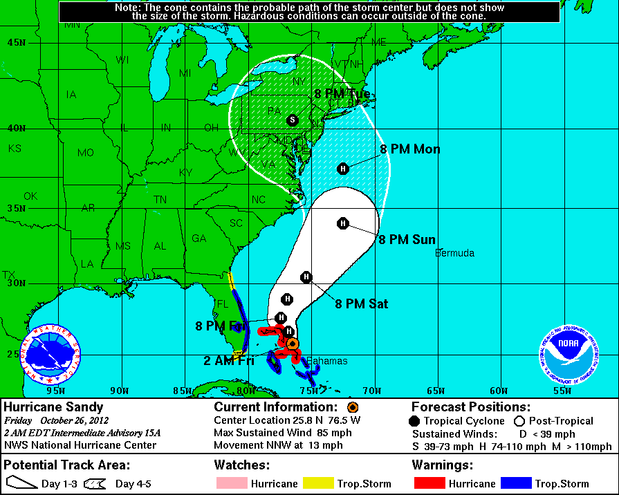
LATEST NATIONAL HURRICANE CENTER UPDATE.

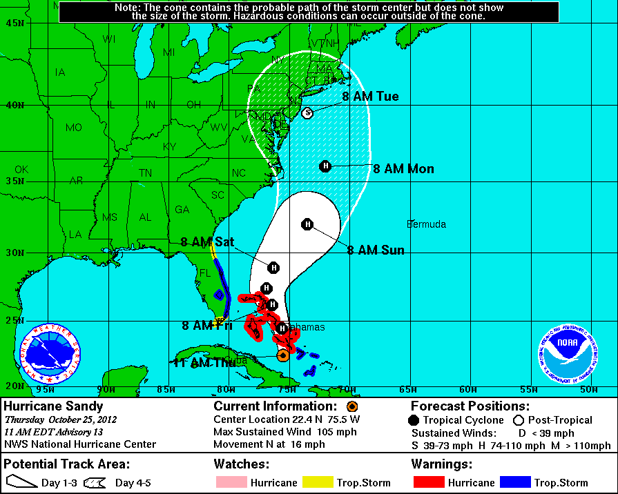
LATEST NATIONAL HURRICANE CENTER WIND FORECAST.
First of all, computer models have come into pretty good agreement that Sandy will get "captured" by the approaching trough from the west either Sunday or Monday then turn W or WNW toward the NE U.S. coast, which is a very unusual track, but a dangerous one for the coastline, especially north and east of where the center makes landfall as the strong onshore winds will combine with tidal surge, leading to widespread beach erosion and power outages.
The timing of when the trough interacts and captures Sandy is key to where and when the center of Sandy will move ashore. The earlier the interaction then the earlier and more south the storm moves inland. The later the interaction, the later and more north the storm moves inland.
Even though the hurricane center may "downgrade" Sandy to a tropical storm before landfall, the main reason for this is the fact that Sandy will be losing some of its tropical characteristics and will become a hybrid, semi-tropical storm, but with a central barometric pressure that lowers back to at least catergory 2 levels as it intensifies toward the coast thanks to the added energy from the trough that is merging with Sandy.
The expected low central pressure with this storm will create a very large field of strong winds, especially north and east of the center.
Don't be fooled into a false sense of security by any "downgrade". This storm will mean business, especially along the coast. Precautions should be taken by the end of tomorrow anywhere from Ocean City, MD to SE New England.
Right now, I favor a center landfall somewhere between Cape May, NJ and Fire Island, LI. Monday night, but coming in from the ESE or SE which is much more rare and more dangerous than the usual southerly approach.
With trees still with plenty of leaves along the Middle Atlantic Coast and LI there will be many downed trees and powerlines.
Looks like high tides will already be running slightly above normal to begin with along the coast Monday through Tue.
Heaviest rainfall will be west and southwest of the track with some areas from perhaps northern Virginia to Pennsylvania and maybe the Catskills easily getting over 5 inches of rain and flooding.
Not too worried about the snow idea, though it does look like there could be a narrow band of heavy, wet snow over the high ground (above 2,500 ft) from northern WV through western PA early next week.
------
Canada impacts
In terms of Canada, latest trends continue to support the idea that the worst of this will be for the NE U.S. states, but expect some decent rain and some gusty winds from southern Ontario through southern Quebec and into the Maritimes the first half of next week. It may be cold enough for snow to fall aloft over Ontario early next week, but I think the low level temperatures will be too warm to support it based on what I see right now.
If the incoming trough ends up slower to the east then the "capture" gets even later and then Sandy could end up turning NW toward Maine or western Nova Scotia no earlier than Tue, but as I have been saying I think this is the least likely option right now, but certainly too early to write off.

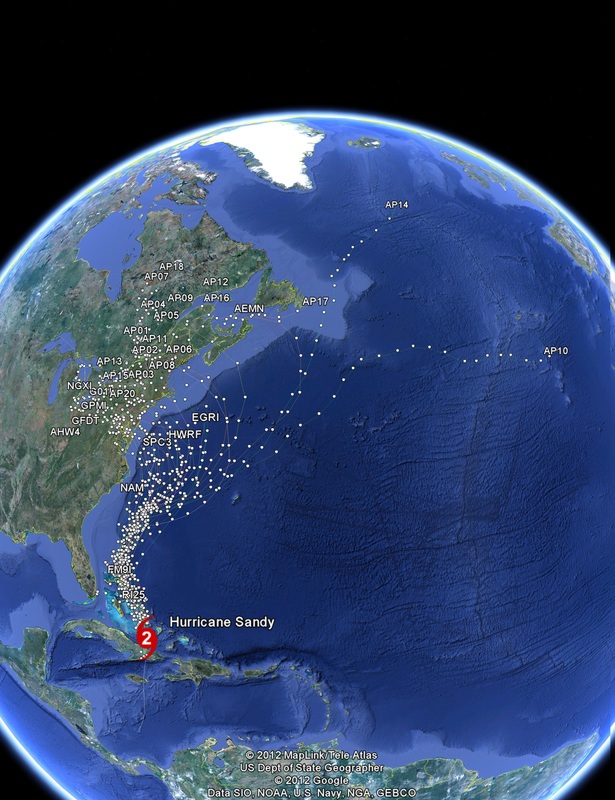
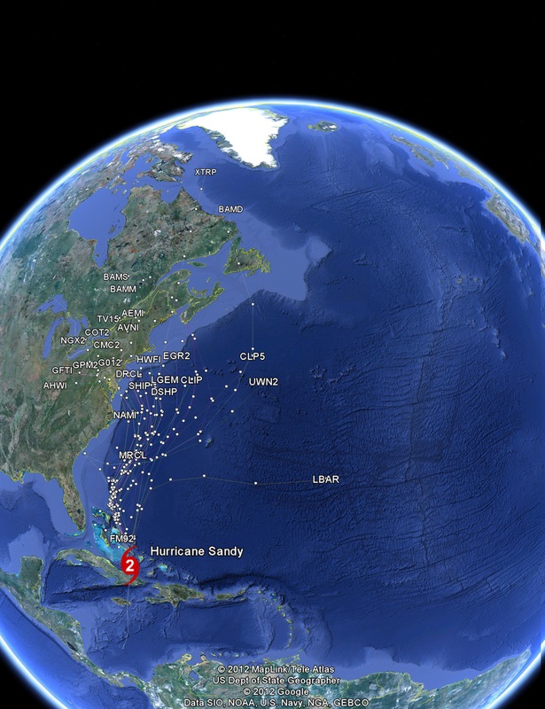
European 00z (7PM) Model on Sandy

European ESTIMATED WINDS

GFS MSL PRESSURE 12Z

CREWS GET READY FOR SANDY IN RHODE ISLAND.


 RSS Feed
