It appears from the latest forecast track from the National Hurricane Center that SANDY will impact the east coast of the United States. We have been told that Jersey Central Power & Light, which was criticized for its response during Irene, says it has placed its employees on alert to be prepared for extended shifts and is monitoring Sandy.
Mt. Holly, New Jersey's National Weather Service issued a Hazardous Weather Outlook which states: HURRICANE SANDY IS FORECAST TO TRANSITION INTO A LARGE COASTALSTORM AS IT MOVES NORTHWARD AND MAY AFFECT OUR AREA IN THE SUNDAY THROUGH TUESDAY TIME FRAME. HEAVY RAINFALL, HIGH WINDS, COASTAL FLOODING AND BEACH EROSION ARE POSSIBLE WITH THIS STORM. HOWEVER, THIS WILL ULTIMATELY DEPEND ON THE EVENTUAL TRACK AND EVOLUTION OF SANDY AS IT INTERACTS WITH A DEEPENING UPPER LEVEL LOW PRESSURE SYSTEM APPROACHING THE EAST COAST.
THERE REMAINS QUITE A BIT OF UNCERTAINTY WITH THE TRACK AND
THEREFORE WITH ANY ACTUAL IMPACTS TO OUR AREA AT THIS TIME.
We have been asked by the New Jersey Office of Emergency Management to post this up: In the meantime, now is a good opportunity to develop/check/update your disaster supply kit and family disaster plan. Think potential impacts: flooding, debris, high winds, and power outages. Our hurricane survival guide is on line. Sandy won't be a hurricane in this area, but the readiness info is good for all hazards: http://www.ready.nj.gov/plan/hurricanes.html
The end game of Sandy is going to be fun. I am sticking to my guns that it is out and around for Sandy and that another storm will brew along the coast due to the very low NAO. In fact, latest NAO shows a value by the 31st of -2.5 which is very low and means that a big storm should be along the coast.
Now while I am sticking to my guns of out and around with secondary development, the other solution is Sandy will come right into New Jersey or New England, although the models remain inconclusive on the track. If Sandy does come right into that area, it will be a major problem in regards to high winds, heavy rains and tidal flooding.
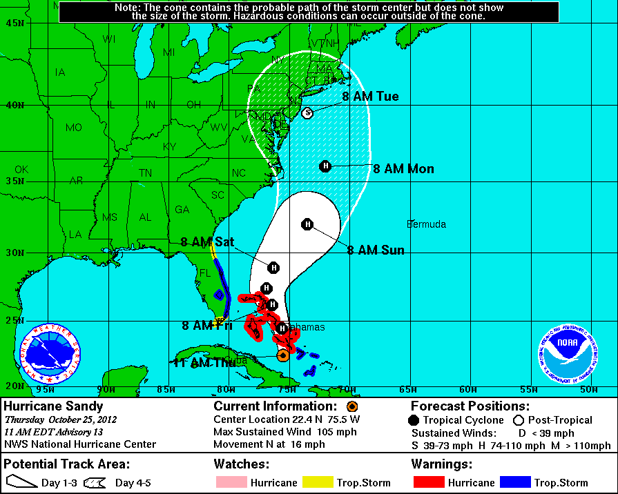
11 AM EDT ADVISORY PATH
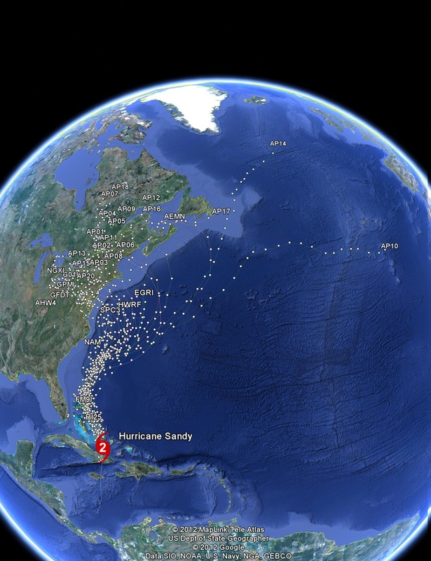
06Z Hurricane Sandy Forecast Track Late Models: This image contains the following models: AEMN, APO1, APO2, APO3, APO4, APO5, APO6, APO7, APO8, APO9, AP10, AP11, AP12, AP13, AP14, AP15, AP16, AP17, AP18, AP19, AP20, AVNO, CMC, CMC2, COTC, FIM9, G01I, GFDL, GFDT, GPMI, HWRF, NAM, NGX, NGX2 and SPC3
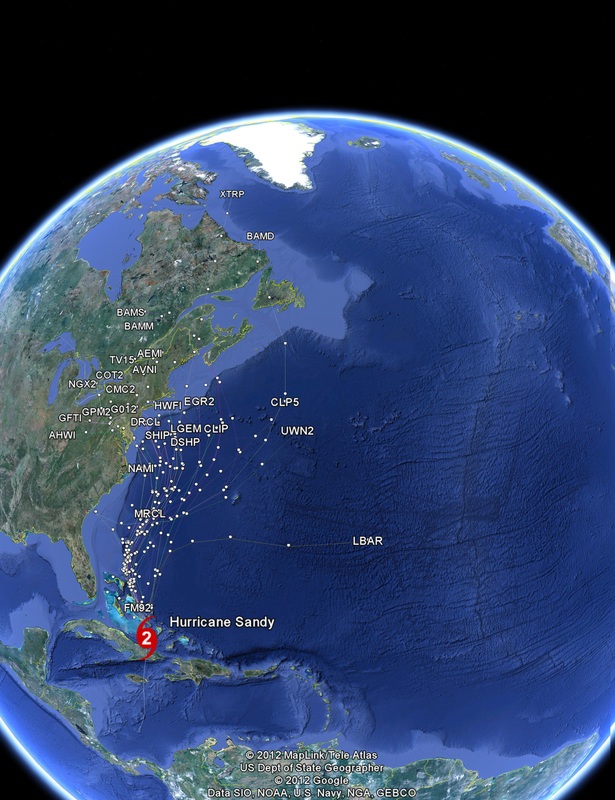
12Z Hurricane Sandy Forecast Track Early Models. This image contains the following models: AEM2, AEMI, AVN2, AVNI, BAMD, BAMM, BAMS, CLIP, CLP5, CMCI, COTI, DRCL, DSHP, FM9U, GFDI, GFTI, GHMI, GPM2, HWFI, LBAR, LGEM, MRCL, NAM2, NAMI, NGXI, OFCI, OFCL, RI25, SHIP, TV15, TVCA,TVCC, TVCE, TVCN, UWN2 and XTRP
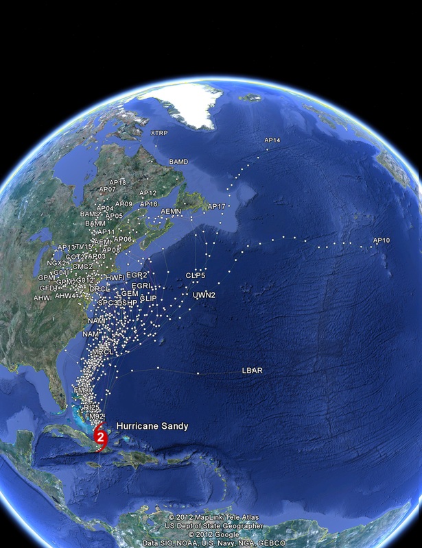
06z and 12z Hurricane Sandy Forecast Track Models. This image contains the following models: AEMN,AEM2, AEMI, AVN2, AVNI, APO1, APO2, APO3, APO4, APO5, APO6, APO7, APO8, APO9, AP10, AP11, AP12, AP13, AP14, AP15, AP16, AP17, AP18, AP19, AP20, AVNO,BAMD, BAMM, BAMS, CLIP, CLP5, CMC, CMC2, CMCI, COTC, COTI, DRCL, DSHP, FM9U, FIM9, G01I, GFDL, GFDI, GFDT, GFTI, GHMI, GPM2, GPMI, HWFI, HWRF, LBAR, LGEM, MRCL, NAM, NAM2, NAMI, NGX, NGX2,NGXI, OFCI, OFCL, RI25, SHIP, SPC3, TV15, TVCA,TVCC, TVCE, TVCN, UWN2 and XTRP
I've been leaning toward this storm being caught by the approaching upper-level trough and forced inland for the end game. Nothing I've seen since yesterday has caused me to change my mind, with the possible exception of being even more concerned about the storm impacts, and the increasing likelihood of the storm hitting anywhere from Cape Hatteras to Montauk.
The one consistent outlier in all of this has been the GFS operational model. It has insisted pretty much all along that Sandy plods along to the north, then northeast, and stays well east of the mid-Atlantic coast. The last few runs have at least shown Sandy getting pulled in at the last minute, with the 0z run favoring a hit on Nova Scotia Wednesday afternoon, and the 6z run striking the Maine coast early Wednesday morning from the east-southeast.
However, if you look at the ensemble runs of the GFS, you get a rather different story. It's almost impossible to read those 12 different weather maps! They're for the 6z run of the GFS ensembles, each one representing a slightly different "perturbation," valid 120 hours out, or 6z Tuesday (wee hours of Tuesday morning). Here's the physical link to that image:
http://www.meteo.psu.edu/~fxg1/ENSPRSNE_6z/ensprsloopmref.html#picture
Meanwhile, the European ensembles are father southwest. The actual operational forecast brings a sub-940 mb low (hard to see exactly how deep it is, but clearly strong than before Sandy made landfall on Cuba early this morning!) into Delaware and southern Maryland late Monday afternoon. The ensemble mean has the center just southeast of Atlantic City, N.J., and would seem to mirror some of the individual members of the 6z GFS ensembles. The window of landfall points may be as far south as Cape Hatteras, and as far north as Nova Scotia. My gut feeling is the window is probably tighter, more like from the Delmarva peninsula to Long Island.
There are a couple of other things to note about Sandy itself. For one, it deepened far more than anyone expected yesterday and last night. In looking at the last couple of recon reports, the pressure appears to be falling again as Sandy moves away from Cuba. For another, Sandy is a huge storm. The clouds extend from the latitude of South Carolina all the way to the southern Caribbean! And a third thing, it is moving along at a good pace, 18 mph at the most recent advisory. The forecasts that had it still south of the latitude of Cape Hatteras Monday morning seem very unlikely at this point, unless it slows down dramatically in the next 48 hours. It will likely slow some as it begins to send the blocking ridge over the northwest Atlantic, but not as much as some of the models had been implying, particularly the aforementioned GFS and its tropical counterparts. The implications of all of the above suggest this storm will come faster. To me, that also suggests less room for escape.
I'm not one given to hyping events all that often. But given the evidence before me, I feel compelled to reiterate many of the concerns I've voiced the past few days about the potential deadly impacts of this storm.
1) Storm surge. Putting numbers to it, we may be looking at a 5- to 10-foot surge near and to the northeast of the landfall point. Remember, the full moon is Monday, so the tides are already going to be abnormally high, so that only increases the height of high tides.
1a) Coastal destruction. This includes many things in combination with the storm surge, the pounding waves and the high winds. This could literally rearrange the coastline, cutting new channels that previously never existed, and severely damaging homes, businesses and infrastructure.
2) High winds over a wide area. As the storm comes north, it will undergo a transformation to something other than purely tropical. Essentially, that will result in an expansion of the wind field, instead of concentrating the highest winds in a smaller area near the core of the storm. In turn, not just the point of landfall may be bracing for winds of 60 to 80 mph or more. It could be over a 200- or 300-mile-wide swath in the worst case scenario, which would lead to widespread downed trees and power outages, extending well inland.
3) Excessive rains. This storm will bring its environment with it from the tropics. As the colder air associated with the upper-level trough and the attendant cold front get injected into it, rather than destroy the storm, it would be like giving it a shot of steroids. That's why some of the pressure forecasts are so extremely low. In turn, this should squeeze that tropical moisture out and produce 5 to 10 inches of rain in many areas, perhaps even higher amounts. That equates to a lot of flooding inland.
4) Heavy wet snow. This will be restricted to the southwest quadrant of the storm, and probably to the higher ground of central and western Pennsylvania and West Virginia. While many trees in these areas have lost their leaves, not all have, and even a few inches of heavy wet snow could add to the carnage. And the potential is there for much, much more.
So, Will Sandy make landfall on the Eastern US. My Gut tells me Yes.
 RSS Feed
